Fifth European Conference on Space Debris
30 March - 2 April 2009
ESA/ESOC
Darmstadt, Germany
Data Sharing to Improve Close Approach Monitoring
and Safety of Flight
| Joseph Chan | Intelsat Corporation |
| Richard DalBello | Intelsat General |
| Dean Hope | Inmarsat |
| Pascal Wauthier | SES-Engineering |
| Tim Douglas | Telesat |
| Travis Inghram | EchoStar Satellite Services |
5th European Conference of Space Debris,
March 30 - April 2 2009
Managing the Space Environment
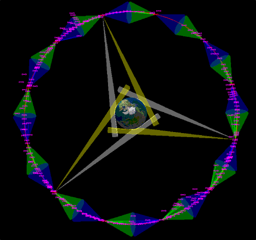
- Space Environment becoming increasingly congested
- Protecting high value assets is a priority for government and commercial actors
- Better coordination among industry and government operators could:
- Provide new awareness of the GEO orbit
- Allow commercial fleets to be flown in a safer manner
- Ensure sustainable use of key orbits
- Reduce likelihood of an accidental crisis
|
 |
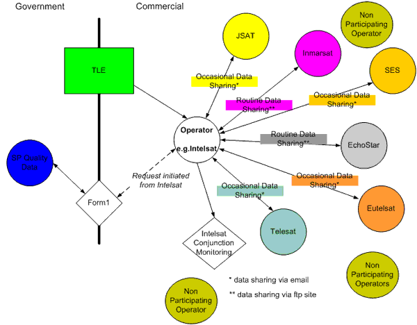
Current Practices on Collision Monitoring
- Publicly available Two Line Elements (TLE)
- Form-1 request via the Air Force Commercial and Foreign Entity (CFE) Program and support from the United States Joint Space Operations Center (JSpOC)
- Informal agreements exist that allow the routine exchange orbital element and maneuver information between operators
- During special operations, such as satellite relocations and transfer orbit operations, special notification is provided which typically includes:
- Latest orbital information
- Near-term maneuver plans
- Frequency information
- Company contact information
- Third party Contract
- Lincoln Lab
- Via Cooperative Research and Development Agreement (CDRA) using the Geosynchronous Monitoring and Warning System (GMWS)
- Semi automated collision risk assessment based on miss distance – operation capability limited to non-active and other CRDA partner satellites in GEO rings
- Monitoring performed with SP equivalent ephemeris data
Shortcomings of Current Approach
- TLE does not have the required accuracy to provide reliable close approaches
- Maneuver information on active satellites are not available to make reliable predictions
- Although helpful Form 1 is inefficient and time consuming two-tier approach to identify potential threats
- No common protocols and format for exchanging orbital and maneuver information
- Not all operators participate in close approach monitoring
The Result?
- Collision risks are increased
- Many close approaches receive little or no attention
- A wider range of threats must be evaluated through inter-operator coordination
- Greater demands are place on government for information and assistance
The Solution?
- Better cooperation between satellite operators
- Better cooperation between governments
- Better cooperation between satellite operators and governments
Cooperation Between Satellite Operators
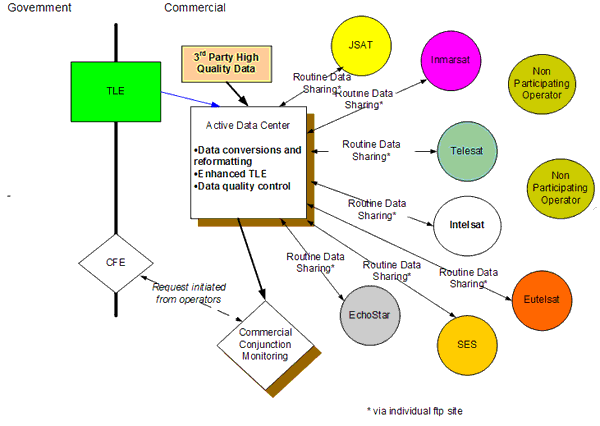
- Data center concept:
- Consortium supported by international satellite operators
- Active processing center – conjunction monitoring and reporting
- Focal point for data exchange – incoming and outgoing
- Member data is protected and secured
- Established rules and protocol based on different levels of conjunction alerts
- Technical support available for close approach mitigation
- Encourage participation in conjunction monitoring
Goals of Data Center
- Enhancing communication:
- Developed protocol for data exchange – from operators to data center and report from data center to operators
- Standardized data exchange format and content
- Common usage and definition of terminologies
- Established operator contact list
- Enhance TLE data:
- Augment TLE with operators’ precision orbit data and maneuver plans
- Encourage data from other sources including radar, optical and other data from different academic institutions, observatories and private/government agencies
Our Vision – Current condition
Our Vision – Data Center Intermediate Phase
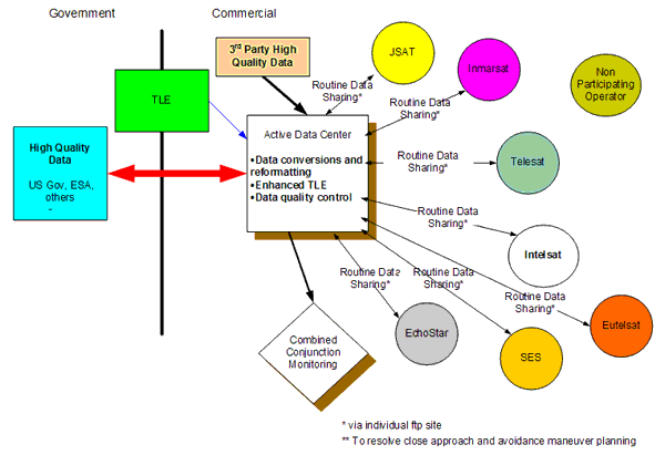
Our Vision – Data Center Final Phase
Initiatives
- 1st Satellite Operators Round Table (Feb 2008, Washington DC)
- Workshop with commercial operators on data sharing and the data center initiative
- Established a prototype of the data center and started data exchange and close approach monitoring
- SOCRATES-GEO developed to facilitate this activity
- Total 7+ partners with data for 115 satellites (Intelsat, Inmarsat, EchoStar, SES, NOAA, Star One, Telesat, …)
- Daily close approach alerts
- Daily neighborhood watch
- 2nd Satellite Operators Round Table (Dec 2008, Ottawa Canada)
- Enhancements to the processing of operators ephemeris data and improvements on reporting
- Benefits to conjunction monitoring with third party ISON data to supplement TLEs
- Importance of calibrating user ephemeris data for reliable close approach monitoring
- Possibility to include RF information
- Outlining the steps needed to make data center operational
Next Steps
- Continue working group to:
- Standardize data quality and exchange format – orbital reference frame definitions, data calibration, uncertainties/covariance, data time span, …
- Enhanced TLE and third party data to improve close approach predictions
- Standardize close approach detection algorithm and process – conjunction box, probabilities and …
- Establish protocol to respond to close approaches
- Reach out to commercial operators, government and international community for support
- Move from a prototype to an operational system
Размещено 10 апреля 2009
Все представленные материалы размещены с согласия авторов докладов
|