59th International Astronautical Congress

Glasgow, Scotland, 29 September - 3 October 2008
USA-193 decay predictions with public domain trajectory data
and assessment of the post-intercept orbital debris cloud
Carmen Pardini & Luciano Anselmo
Spaceflight Dynamics Laboratory – ISTI/CNR – Pisa, Italy
At the beginning of 2008, the need arose to predict the orbital decay of the American spacecraft USA-193, whose characteristics, function and orbit were classified
With no orbit data and independent Italian tracking capability, we turned our attention, for the first time, to the orbits determined by a worldwide network of about 20 visual satellite observers
OUTLINE
THE USA-193 SATELLITE
- Launch date - 14 December 2006
- Launch site - Vandenberg (California)
- Launcher - Delta II 7290
- Catalog number - 29651 (2006-057A)
Mission, payload and characteristics were classified
Suspected mission - new type of high resolution radar imaging spacecraft (E-305) and part of the Future Imagery Architecture (FIA), developed by the National Reconnaissance Office (NRO)
No official mission and orbit data were provided
Hours after the launch, the spacecraft suffered a fatal failure, but its premature loss did not change its classification status, so no unclassified TLE was issued by the US SSN
OBSERVATIONS OF USA-193
The satellite was observed by a worldwide network of about 20 amateur visual observers
The orbits
- were determined from visual observations and freely distributed through the Visual Satellite Observers’s and the Heavens-Above web sites
- were mainly determined and issued in the TLE format by Ted Molczan, based in Toronto, Canada
Amateur optical observations
- allowed the initial orbit determination: the dead satellite had been placed into a 351 x 367 km orbit, with inclination of 58.5°
- suggested a tumbling attitude, and telescopic CCD images showed an approximately 3 x 3 x 4 m box without solar panels (the premature satellite failure would have in fact prevented the solar arrays and main antenna deployment)
- confirmed, during the following months, that the orbit was not controlled, but decaying due to the effect of atmospheric drag
Circumstantial evidence, international regulations, reliable open sources hinted that no nuclear power source was on board
REENTRY PREDICTIONS
In January 2008, following the worldwide reports indicating an imminent uncontrolled reentry of USA-193, the Space Flight Dynamics Laboratory of ISTI/CNR mobilized to provide reentry predictions and risk assessment.
- The orbits used were those freely distributed through the Visual Satellite Observer’s and Heaven-Above web sites
- At the beginning of our analysis, on 22 January 2008, USA-193 had decayed to 275 x 280 km
- From 22 January to 21 February 2008, 20 TLE based on visual observations were issued (with observation gaps of 2-5 days), acquired and processed
- Also 11 “historical” TLE – from 15 December 2006 to 4 April 2007 – were found. They were used to model the satellite long-term decay and to characterize its aerodynamic properties
- Reentry predictions were obtained using a numerical special perturbations propagator, SATRAP, with a 16 x 16 gravity field, luni-solar attraction, direct solar radiation pressure with eclipses and atmospheric drag
- The Jacchia-Roberts 1971 thermospheric density model was selected for this specific event. In one case MSISE-90 was used as well for comparison
- The ballistic parameter B = CDA/M was estimated by fitting, in a least squares sense, the semimajor axis decay described by a set of TLE (typically between 10 and 20), preceding the reentry prediction epoch
The reentry predictions were very stable, a result certainly favored by the low and steady solar and geomagnetic conditions
| Prediction Date | Estimated Reentry Time |
|---|
| 22 January 2008 | 10 March 2008, 04:55 UTC |
| 31 January 2008 | 12 March 2008, 04:31 UTC |
| 4 February 2008 | 13 March 2008, 14:02 UTC |
| 7 February 2008 | 12 March 2008, 21:23 UTC |
| 10 February 2008 | 12 March 2008, 21:37 UTC |
| 11 February 2008 | 13 March 2008, 10:11 UTC |
| 17 February 2008 | 13 March 2008, 04:38 UTC |
| 18 February 2008 | 12 March 2008, 14:41 UTC |
| 19 February 2008 | 12 March 2008, 11:03 UTC |
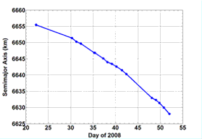
USA-193 observed semimajor axis evolution
The orbit evolution was quite smooth, and the trajectory propagations maintained a good predictive value over several days, due to the good estimations of B and low and stable solar activity conditions�� The orbit determinations based on the visual observers data were accurate and precise |
 |
The public domain orbital data were very useful and precious for predicting the dynamical evolution of USA-193 and determining some of its classified properties, like the mass
MASS ESTIMATION
The value of the estimated USA-193 ballistic parameter remained considerable steady and consistent during the time span considered
- The mean value obtained with JR-71 was
B = CD A / M = 0.012112 ± 0.000327 m2/kg
- The single value obtained with MSISE-90, on 17 February 2008, was
B = CD A / M = 0.011440 m2/kg
Assuming CD = 2.2 and A = 13.2 m2 (the cross-section of a sphere having the same volume of the box suggested by the John Locker’s CCD images: 3 x 3 x 4 m), it was possible to obtain the following estimates of the USA-193 mass
M ~ 2398 ± 65 kg, with JR-71
M ~ 2538 kg, with MSISE-90
The mass estimates were compatible with launcher performances and initial orbit
The masses often quoted in the press and the media (from 5 to 10 tons) were completely unrealistic
REENTRY RISK ASSESSMENT
Using the USA-193 estimated mass, it was possible to execute a rough risk assessment, by extrapolating the results of previous studies, e.g. BeppoSAX (1350 kg), simulations for NASA S/C of varying mass (from 2.6 to 15 metric tons), recovered debris on the ground
- The USA-193 estimated casualty area was ~ 60 m2
- The debris footprint was ~ 50 km wide and ~ 500 km long, in the direction of the sub-satellite ground track
- The macroscopic fragments able to survive the conditions encountered during the reentry would have hit the ground along the local vertical, neglecting the winds, with impact speeds in between 50 and 500 km/h
- Assuming an average population density of 15.34 inhabitants per km2 in the applicable latitude band (± 58.6°), the estimated casualty area translated into a casualty expectancy of ~ 10-3 (one order of magnitude more than the “alert threshold” informally adopted at international level)
- The a priori probability of debris fall in Italy remained well below 1%
Frozen hydrazine (~ 450 kg on board) might have reached the ground inside the tank (d ~ 1 m), but with no significant increase of the risk
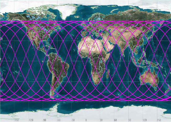
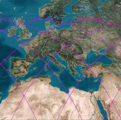
USA-193 SUB-SATELLITE GROUND TRACK
DURING ONE DAY OF THE THIRD WEEK OF FEBRUARY 2008
Data and TLE gaps of 2-6 (even 8) days were observed during the last month spent in orbit by USA-193
Therefore it was not possible to exclude a final reentry window of 24-48 hours
However, a maximum of two critical passes over Italy would have been possible every 24 hours, allowing to plan meaningful civil protection measures
THE DESTRUCTION OF USA-193 [1]
On 14 February 2008 the US Government publicly announced its intention to destroy USA-193 in space
The unprecedented move was justified by the need to destroy a 1-meter spherical propellant tank filled with about 450 kg of (mildly) toxic hydrazine. So, even though the probability of hitting a populated area was remote, the decision to destroy the satellite was considered the safest option.
Details of the operation were deduced from a series of NOTAM (Notice to Airmen) issued since 18 February 2008
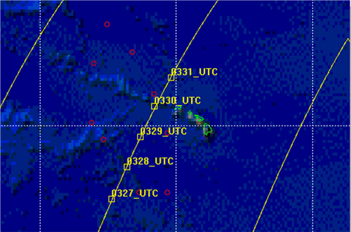
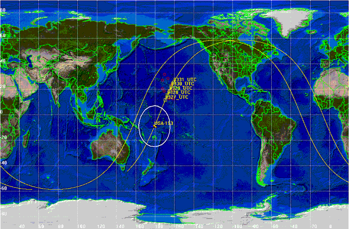
USA-193 first interception opportunity
from 03:28 and 03:30 UTC of 21 February 2008
The red circles delimit the area identified by the geographic coordinates provided in the NOTAM
The predicted trajectory of the satellite is shown in yellow
At last, the USA-193 “kinetic engagement” occurred
At 03:26 UTC of 21 February 2008, a modified SM-3 missile, carrying a Lightweight Exo-Atmospheric Projectile Kinetic Warhead (LEAP KW), was fired from the Aegis cruiser USS Lake Erie, stationed west of the Hawaii Islands (23.482° N, 163.282° W).
At 03:29:37 UTC the satellite was centrally hit by the homing kill vehicle, at a relative impact velocity of about 9.8 km/s, and a catastrophic breakup occurred.
Orbital elements of USA-193 when the fragmentation occurred
Breakup Epoch: 21 Feb 2008, 03:29:37 UTC |
|---|
| Keplerian Elements (J2000 ECI) |
|---|
| Semimajor axis | 6631.891 km |
| Eccentricity | 0.002492 |
| Inclination | 58.510° |
| Right ascension of ascending node | 25.454° |
| Argument of perigee | 87.707° |
| True anomaly | 297.097° |
| Mean anomaly | 297.351° |
| Geodetic Coordinates |
|---|
| Latitude | 21.122° N |
| Longitude | 163.705° W |
| Altitude | 248.953 km |
| Position and Velocity (True of Date) |
|---|
| X component (km) | 4796.499476 |
| Y component (km) | 3903.951291 |
| Z component (km) | 2373.717429 |
| VX component (km/s) | - 4.542512 |
| VY component (km/s) | 1.904807 |
| VZ component (km/s) | 5.998171 |
THE DEBRIS CLOUD
The destruction of USA-193 generated a substantial debris cloud
- More then 50% of the fragments were not orbital and reentered within 45 minutes of the event [Johnson N.L., 26th IADC Meeting, Moscow, April 2008]
- Many reentering debris trails were in effect witnessed in Canada around 03:43 UTC [Visual Satellite Observer’s Home Page, 2008]
- During the day following the breakup, the orbits of 360 debris larger than 5 cm were determined [Orbital Debris Quarterly News, Vol. 12, N. 2, 2008; Johnson N.L. 26th IADC], but many of them decayed too rapidly, leading to only 173 officially cataloged objects
- One fragment was hurled into an orbit with an apogee altitude of 3250 km
- Inclination changes up to 3.8° were observed, therefore velocity variations up to ~ 700 m/s were imparted to the debris
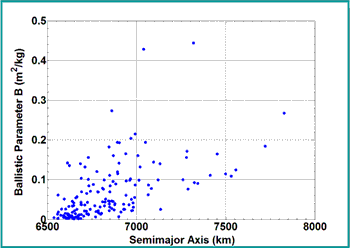
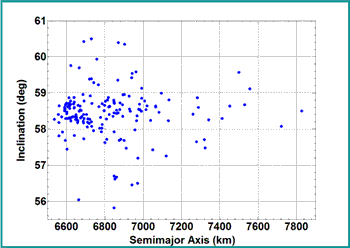
DEBRIS CLOUD DISTRIBUTION
Distribution of the ballistic parameter, semimajor axis, eccentricity and inclination of the cataloged fragments
 |
 |
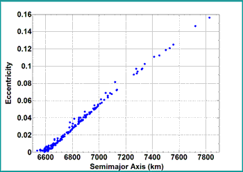 |
The cloud of cataloged objects was short-lived and did not increase significantly the impact risk in low earth orbit |
IMPACT RISK IN LEO DUE TO THE USA-193 BREAKUP
However
- The liftoff from the Vandenberg Air Force Base of a classified reconnaissance spacecraft (NROL-28) atop an Atlas V rocket, initially slated for 29 February 2008, was delayed for at least two weeks to avoid the orbiting remains of USA-193
- The impact risk for the ESA’s Jules Verne Automated Transfer Vehicle (ATV), launched towards the International Space Station from Kourou, French Guiana, on 9 March 2008, increased by a factor 2 at the beginning of the cruise phase, although the background debris flux was moderate and the risk level decreased quickly [Krag H., 26th IADC Meeting, Moscow, April 2008]
- Concerning the International Space Station (ISS), at a mean altitude of about 335 km, the cumulative risk due to the USA-193 cloud of fragments was equivalent, according to the NASA estimates, to approximately 2-3 days of exposure to the pre-event space debris environment [Johnson N.L., 26th IADC Meeting, Moscow, April 2008]
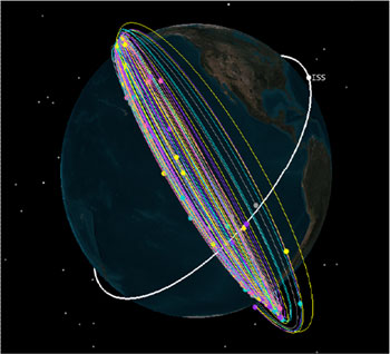
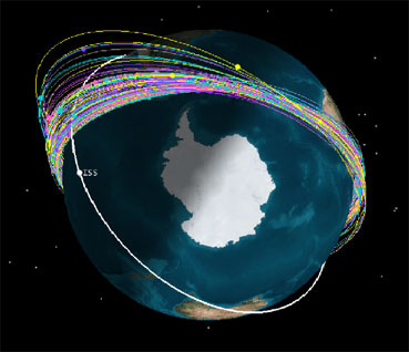
DISTRIBUTION OF THE ORBITS OF THE USA-193 FRAGMENTS WITH RESPECT TO THE ISS TRAJECTORY ON 7 MARCH 2008
 |
 |
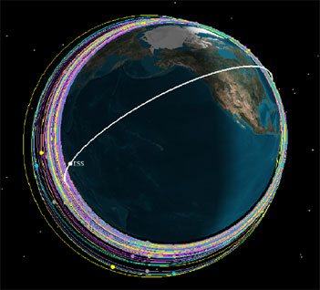 |
...about 15 days after the breakup |
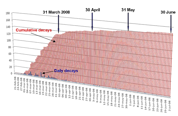
ORBITAL DECAY OF DEBRIS
The observed decay rate basically confirmed our rough reentry predictions
Cataloged fragments reentered by the end of
| March: | 75.1% |
| April: | 89.0% |
| May: | 95.4% |
| June: | 98.3% |
At the end of July 2008 only two objects remained in orbit: 32601 and 32657
By fitting the semimajor axis decay observed over 1 month (~ 70 TLE), we found
B = 0.05378 m2/kg for object 32601
B = 0.02953 m2/kg for object 32657
Our estimated orbital decay was at the end of August 2008 for object 32601 (Actually decayed on 30 August 2008) and during the fourth week of October 2008 for object 32607, i.e. eight months after the satellite destruction
CONCLUSIONS
The USA-193 story was an extraordinary example of many of the problems faced in dealing with orbital debris research and mitigation efforts
- The lack of critical information
- The often exaggerated misconceptions of the general public, fed by a too complacent media system
- Competing security and safety needs
- International regulations and space policy concerns
- The secrecy surrounding military programs
- The phantom of an arms race in space
- The risk of causing casualties on the ground
- The risk of damaging precious satellite assets in orbit
all these aspects concurred to render this experience very instructive and unique
In spite of the limitations and constraints, we hope to have demonstrated that a serious and helpful analysis work was possible even in this case, exclusively searching for and using reliable public domain data sources.
5 октября 2008
Материалы докладов публикуются с согласия авторов
|